Innovative Emergency Response System Aids Helene Rescue Operations

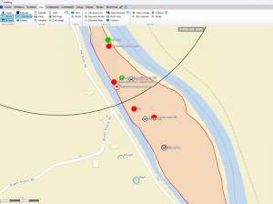
Video Feed from helicopter on AGIS system
Rescuers committed to support communities in crisis leveraged advanced technology to enhance disaster response
JUPITER, FL, UNITED STATES, February 10, 2025 /EINPresswire.com/ -- A state-of-the-art emergency response system, utilizing GPS-tagged dogs and repurposed military computer communications and satellite processing, has innovated for extended and new capabilities for rescue operations. In response to the devastating impact of Hurricane Helene, AGIS Inc. has partnered with Cloud WAN Solutions (CWS) to provide critical support to the communities of Asheville, Boone, and Banner Elk, North Carolina.
These areas have been severely affected, with impassable roads hindering the delivery of essential supplies and assistance.
To address this challenge, AGIS Inc. adapted its military-oriented CJADC2 software to develop a civilian Common Operational Picture (COP) system, which has been donated to volunteer disaster responders using private helicopters. This system enhances visualization, communication, and collaboration, assisting in tracking and coordinating response efforts and locating affected individuals. All efforts have been undertaken pro bono.
Satellite Imagery and Support
Contributors such as Maxar Technologies, supported by the U.S. Space Command, have provided up-to-date satellite imagery to identify locations that are cut off and lack communications. By comparing pre- and post-Hurricane Helene satellite imagery, disaster responder teams can accurately assess the extent of the damage. Starlink mini terminals have been installed in helicopters to enable the broadcast of video from the areas of devastation and to coordinate activities between personnel on the ground and the Command Center.
Prior Experience in Integration
For the past two years, AGIS Inc. and CWS have collaborated on various initiatives, supporting several Marine Corps exercises by integrating AGIS’s CJADC2 C5ISR software with CWS’s technology. They have successfully participated in U.S. Navy exercises, including Silent Swarm and Northern in Alpena, MI, and FLEX24 in Key West, FL. The experience gained from these exercises has been applied to their Hurricane Helene response efforts.
Novel Use of Rescue Dogs to Transmit Data
Disaster response companies with highly trained rescue dogs have joined the relief efforts. GPS devices attached to the dogs’ collars automatically transmit real-time location data, which is read into CalTopo mapping software. This allows users to create, update, and share customized maps for navigation and planning.
Data from CalTopo is stored in KML format and then sent to the AGIS C5ISR system, where it is stored as a layer that can be overlaid on the georeferenced map and automatically shared with others on the AGIS C5ISR network. This data can be used to schedule and direct helicopter searches using AGIS’s C5ISR chat, messaging, and video capabilities. AGIS’s software enhances CalTopo operations by facilitating the automated integration of location data from various sources, minimizing manual data entry, and reducing the likelihood of human errors.
The AGIS software also provides encrypted voice, data, and video communications. It enables video transmission from CalTopo phones to other rescue responders and to helicopters equipped with this software, ensuring real-time updates and effective coordination.
Comprehensive System Features
This advanced system provides rescue teams with a map-based, video-enhanced COP that allows users to enter map symbols and attach amplifying voice, text, documents, images, and video to a symbol on the map, viewable by simply touching the symbol. This feature offers a comprehensive view of the available details related to the areas of devastation, which is particularly valuable in large-scale search efforts where time and resources are limited.
Rescue team leaders can identify areas requiring immediate attention and optimize the use of available assets and personnel. On the ground, dog handlers receive data indicating if their dog has stopped moving, potentially signifying the location of a person or an encountered hazard, allowing for quicker responses and decision-making.
The integration of AGIS C5ISR software provides several benefits, including:
• Up-to-date satellite imagery of the area.
• The ability to see the COP, including operators at the Command Center.
• Real-time helicopter location tracking and communication with search teams using encrypted PTT, voice, and video calls, chat, messaging, and must-respond orders.
• The ability to declare emergency situations and draw on maps and satellite images for instant area designation using commonly understood symbols.
AGIS Inc. remains dedicated to supporting communities in crisis and leveraging advanced technology to enhance disaster response efforts.
See a video of AGIS capabilities here https://www.agisinc.com/videos/LRFR-web.mp4
For information, contact Cap Beyer at beyerm@agisinc.com or at 561-744-3213.
To get the latest version of any Thick client apps, go to www.agisinc.com/download
To try the AGIS Web client system, go to either www.liferingmilitary.com _or_ www.liferingfirstresponder.com
Made in the USA by American Citizens.
Cap Beyer, CEO
Advanced Ground Information Systems (AGIS), Inc.
+1 561-744-3213
beyerm@agisinc.com
Visit us on social media:
LinkedIn
AGIS First Responder C5ISR
Distribution channels: Aviation & Aerospace Industry, Emergency Services, Military Industry, Natural Disasters, Technology
Legal Disclaimer:
EIN Presswire provides this news content "as is" without warranty of any kind. We do not accept any responsibility or liability for the accuracy, content, images, videos, licenses, completeness, legality, or reliability of the information contained in this article. If you have any complaints or copyright issues related to this article, kindly contact the author above.
Submit your press release

